The Use of Topographical Surveys in Modern Land Development
Land development projects should be planned and implemented with utmost precision. Constructing a new building, constructing infrastructure, or managing land resources means having reliable information about the topography of the land. Topographical surveys supply that.
A topographical survey is a precise map of both natural and man-made entities of a piece of land. Through height and gradient to vegetation, utility, and constructions, such surveys will give the engineers, architects, and planners the stack of details they need to be optimistic that they can build.
What Is a Topographical Land Survey?
Topographical land survey involves measuring and mapping the physical aspects of the site. In contrast to general boundary surveys, which identify only the property lines, Topographical surveys record everything that can be seen on the ground. These include:
Ground elevation and contours
Roads, fences, and trails
Structures, buildings, and utilities
Natural elements like rivers, trees, and hills
This comprehensive data provides an accurate image of the site at the moment, making plans for the future a reality.
Why Topographical Surveys Are Important
Topographical surveys are an important component of many projects, including:
Preparation for construction – Guaranteeing foundations, drainage, and utilities are designed to accommodate the actual ground.
Land development – Identifying opportunities and constraints for intended house, commercial, or industrial proposals.
Infrastructure – Facilitating road, bridge, and utility planning through accurate elevation and contour data.
Environmental management – Tracking natural change on the ground, for example, erosion or flood hazard.
Investment in precise surveying has the potential to save project teams costly errors and minimize redesigns or delays in construction.
Topographical Survey Cost
Probably the most frequently ordered by clients is the cost of the topographical survey. The cost will vary depending on such things as:
Site area – Larger sites require more time and effort.
Complexity of features – Heavily landscaped city sites with more utilities and buildings demand more complex work.
Deliverables that are required – Simple contour maps cost less than full CAD or BIM-ready outputs.
Methodology utilized – More costly conventional surveys may be, but new methods, such as laser scanning, are more rapid and accurate.
Increased up-front cost is certain, but long-term advantages are exceptional. Accurate surveys eliminate expensive mistakes, saving time and money invested in project implementation.
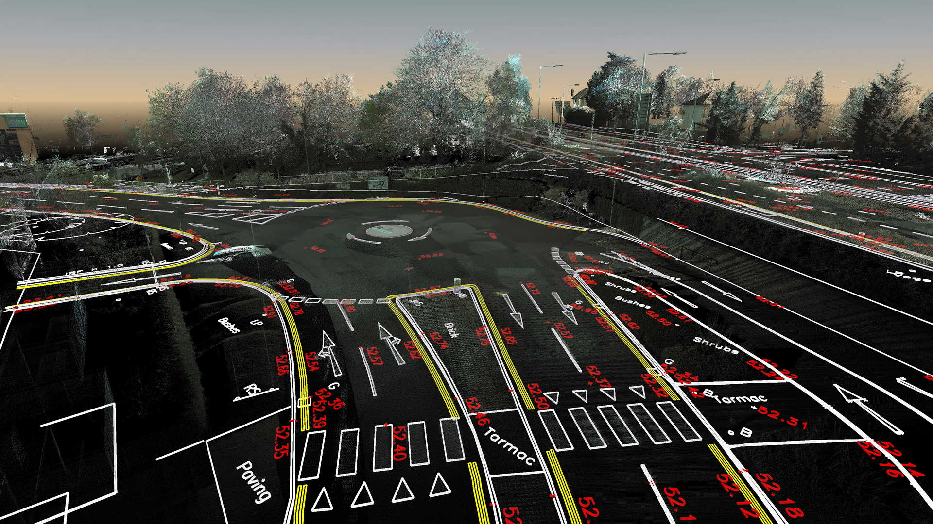
The Contribution of 3D Scanning and Point Clouds
Increasingly, 3D laser scanning is being used in modern surveying to collect topography data efficiently and accurately. Scanning provides a point cloud, an intensive set of millions of points that describe the ground surface very accurately.
Using point clouds, engineers and surveyors can transform the point cloud into a 2D drawing, enabling them to produce the correct plans to be used in CAD or BIM software. 2D drawings are easier to share, interpret and use in the design processes of a project, the loop between raw data and usable project records.
Advantages of Modern Topographical Surveys
With the interaction of the old school technique and advanced 3D scanning, topographical surveys today offer more than ever. A few of the benefits are:
Speed – Laser scanning is completed within a few hours in large regions.
Accuracy – Millimetric accuracy reduces the likelihood of design errors.
Versatility – Data can be repurposed in future projects or converted into 2D and 3D models.
Collaboration – Computerized survey findings can easily be distributed to stakeholders.
The advantages of such surveys make modern-day surveys a requirement for advanced projects where urgency and accuracy are required.
Finding the perfect partner
Surveys are not created equal. When a client selects a provider, he or she needs to look for experience in conventional surveying techniques in addition to experience in the newer technology of laser scanning. Point cloud to 2D drawing capability is also better since it enables data to be delivered exactly in the format that engineers and designers need.
It is also necessary that one equates the topographical survey price and quality. The lowest priced is not necessarily the best to go for when it comes to high-risk projects, but spending money on trained surveyors will repay one later in savings from avoiding expensive blunders.
Final Thoughts
From modest building projects to massive infrastructural development schemes, topographical surveys are the driving force of successful land development. Giving precise, accurate information on the ground, they enable planners, engineers, and developers to make good decisions at all times.
Whether it is high-end laser scanning, point cloud to 2D drawing, or topographical land survey, these services offer the precision and clarity that is required in today's competitive business. While the topographical survey price may be different, its accuracy, efficiency, and long-term cost savings cannot be argued with.
In an era where growth is data-driven, topographical surveys make sure that every project is constructed on the pillars of accuracy.